Using abmi.camera.extras
This package provides access to the Alberta Biodiversity Monitoring Institute’s (ABMI) camera-level animal density estimates, which can be used to estimate the density (and associated confidence bounds) of various species in a user-defined area of interest.
This package currently contains data from ABMI camera deployments put out between 2014 and 2019, as well as data on the following species:
- White-tailed Deer
- Mule deer
- Moose
- Elk (wapiti)
- Black Bear
- Coyote
- Pronghorn
- Snowshoe Hare
- Woodland Caribou
- Canada Lynx
- Gray Wolf
Current (as of 2019) geographic coverage of sampling in the province can be seen in the map below:

Note that there are four cameras deployed at each ABMI site, 600-m apart. Each point on the plot represents a site, which has four deployments. See here for detailed explanation of remote camera trap protocols.
Features
The primary objective of this package is to allow users to estimate the density of a species of interest in an area of interest. For this objective, three steps are neccessary:
- Spatially subset ABMI camera deployments by a user-supplied area of interest (or multiple);
- Join pre-processed individual deployment density estimates to this spatial subset of cameras;
- Summarise density for the area of interest as a whole, including confidence bounds.
Usage and Recommended Workflow
# Load package
library(abmi.camera.extras)

# Load packages for working with spatial data and plotting results
library(sf)
# Note: sp objects will also work.
# library(sp)
library(ggplot2)
The first step is to define an area of interest, such as a Wildlife Management Unit, Municipality, Land Use Planning Region, etc. Below, this is done using the sf package to read into R a shapefile of four WMUs - Crow Lake (code 512), Lac La Biche (503), Beaver River (502), and Amisk (504) - all of which are located in the central-east part of Alberta.
# Define aoi
sf_wmu <- sf::st_read(system.file("extdata/wmu_sample.shp", package = "abmi.camera.extras"), quiet = TRUE)

# Take a look at structure and attributes
tibble::glimpse(sf_wmu)
## Rows: 4
## Columns: 6
## $ OBJECTID   <dbl> 25, 34, 49, 50
## $ WMUNIT_NAM <chr> "Crow Lake", "Lac La Biche", "Beaver River", "Amisk"
## $ WMUNIT_COD <chr> "00512", "00503", "00502", "00504"
## $ Shape_STAr <dbl> 8018929846, 3220514507, 3585827617, 2704241428
## $ Shape_STLe <dbl> 476404.3, 355774.1, 293530.4, 252285.2
## $ geometry   <POLYGON [m]> POLYGON ((754560.7 6209247,..., POLYGON ((713202...
Next, we subset ABMI camera deployments spatially with the ace_get_cam() function:
# Retrieve deployments in aoi as dataframe
df_deployments <- ace_get_cam(aoi = sf_wmu,
                              group_id = WMUNIT_NAM, # Use `id` to define identifier (e.g. WMU name)
                              crs = 4326) # If desired, (re)project using the `crs` argument

# Plot deployments
sf_wmu <- st_transform(sf_wmu, "+init=epsg:4326")
plot(df_deployments$geometry, pch = 21, cex = 0.7, col = "#2D415B", bg = "gray80")
plot(sf_wmu$geometry, border = "gray20", col = NA, add = TRUE)

# Remember that each point represents an ABMI site, which has four camera deployments spaced 600-m apart.
Users may wish to spatially subset their own dataframe of camera deployments locations, instead of retrieving the ABMI’s. This can be done by supplying the dep = argument in ace_get_cam(), along with specifying which columns hold the lat/long coordinates in the coords = argument.
From here we can join density estimates for a species of interest in a given sampling period for each deployment using the ace_join_dens() function:
# Join density
df_dens <- ace_join_dens(x = df_deployments,
                         species = c("Moose", "White-tailed Deer"), # See ?ace_join_dens for list of available species
                         # samp_per = "2018", option to define specific sampling period if desired
                         nest = FALSE)

head(df_dens, 10)
## Simple feature collection with 10 features and 5 fields
## geometry type:  POINT
## dimension:      XY
## bbox:           xmin: -112.6051 ymin: 55.9708 xmax: -112.2392 ymax: 55.97986
## geographic CRS: WGS 84
##           name samp_per WMUNIT_NAM       common_name   density
## 1  ABMI-632-NW     2015  Crow Lake             Moose 2.0960753
## 2  ABMI-632-NW     2015  Crow Lake White-tailed Deer 8.7893520
## 3  ABMI-632-SE     2015  Crow Lake             Moose 1.8495771
## 4  ABMI-632-SE     2015  Crow Lake White-tailed Deer 0.5805277
## 5  ABMI-632-SW     2015  Crow Lake             Moose 1.6909176
## 6  ABMI-632-SW     2015  Crow Lake White-tailed Deer 3.0587292
## 7  ABMI-633-NE     2015  Crow Lake             Moose 0.0000000
## 8  ABMI-633-NE     2015  Crow Lake White-tailed Deer 0.0000000
## 9  ABMI-633-NW     2015  Crow Lake             Moose 0.0000000
## 10 ABMI-633-NW     2015  Crow Lake White-tailed Deer 0.0000000
##                      geometry
## 1  POINT (-112.6051 55.97986)
## 2  POINT (-112.6051 55.97986)
## 3  POINT (-112.6051 55.97986)
## 4  POINT (-112.6051 55.97986)
## 5  POINT (-112.6051 55.97986)
## 6  POINT (-112.6051 55.97986)
## 7   POINT (-112.2392 55.9708)
## 8   POINT (-112.2392 55.9708)
## 9   POINT (-112.2392 55.9708)
## 10  POINT (-112.2392 55.9708)
Note that the samp_per column refers to sampling period, which, in the case of the ABMI, is done yearly.
The distribution of density values is typically right-skewed, with most cameras not detecting any individuals (0 density), some that detect a small number of individuals just passing by (low density), and a few who capture longer periods of animal activity (high density).

The last step is to estimate the density of each of the species defined previously in the area of the interest, which can be done with the ace_summarise_dens() function.
# Summarise density
df_dens_summary <- ace_summarise_dens(x = df_dens,
                                      group_id = WMUNIT_NAM, # to group deployments when evaluating multiple aoi or treatments
                                      agg_samp_per = TRUE, # option to aggregate sampling periods
                                      samp_per_col = samp_per, # to indicate which column refers to sampling period to group on
                                      species_col = common_name, # to indicate which column refers to species to group on
                                      dens_col = density, # column where density values are held
                                      conflevel = 0.9) # for confidence interval - default 90%
Note that ace_summarise_dens() can be used independently of the first two functions if the user wishes to summarise external density data. If supplying your own dataframe (i.e. df_dens), rather than using output from the first two functions, make sure that the data is formated in a tidy way. Each row should represent an observation of density at a single deployment, and each column a variable (e.g. species, treatment, sampling period). The arguments samp_per_col, species_col, and dens_col can be used to customize the call of ace_summarise_dens to suit your data.
The output is a dataframe with the following attributes (beside the grouping variable, year, and species):
-
occupied- number of deployments with a individual of that species present -
n_deployments- total number of deployments -
prop_occupied- proportion of deployments occupied -
density_avg- estimated density for the area/year/species combination -
density_lci- lower bounds of confidence interval (level specified inconflevelattribute) -
density_uci- upper bounds of confidence interval
The precision of the density value is estimated through Monte Carlo simulation using the delta method. Note that some ABMI camera deployments are set up with a lure; the subsequent density estimates have been adjusted to facilitate comparison with non-lured estimates when summarising animal density for an aoi.
Note that this family of three functions is designed to work with a pipeline-based workflow, and can be re-written in the following way:
# Pipeline workflow
df_dens_summary <- sf_wmu %>%
  ace_get_cam(group_id = WMUNIT_NAM) %>%
  ace_join_dens(species = c("Moose", "White-tailed Deer")) %>%
  ace_summarise_dens(group_id = WMUNIT_NAM, agg_samp_per = FALSE,
                     samp_per_col = samp_per, conflevel = 0.9)

# Results from Crow Lake WMU
df_dens_summary %>%
  ungroup() %>%
  mutate(common_name = ifelse(common_name == "White-tailed Deer", "WTD", common_name)) %>%
  rename(WMU = WMUNIT_NAM, year = samp_per, species = common_name) %>%
  filter(WMU == "Crow Lake") %>%
  mutate(WMU = "512") %>%
  arrange(species, year) %>%
  kable()
| WMU | year | species | occupied | n_deployments | prop_occupied | density_avg | density_lci_0.9 | density_uci_0.9 |
|---|---|---|---|---|---|---|---|---|
| 512 | 2015 | Moose | 6 | 15 | 0.4000000 | 0.4191881 | 0.1958320 | 0.6737829 |
| 512 | 2016 | Moose | 10 | 24 | 0.4166667 | 0.4972947 | 0.2871185 | 0.7336256 |
| 512 | 2017 | Moose | 6 | 24 | 0.2500000 | 0.2781682 | 0.1140484 | 0.4923659 |
| 512 | 2018 | Moose | 4 | 15 | 0.2666667 | 0.2258010 | 0.0612437 | 0.4340766 |
| 512 | 2015 | WTD | 8 | 15 | 0.5333333 | 2.1687743 | 1.2185272 | 3.2229538 |
| 512 | 2016 | WTD | 17 | 24 | 0.7083333 | 0.2744533 | 0.1988421 | 0.3565054 |
| 512 | 2017 | WTD | 7 | 24 | 0.2916667 | 0.1913708 | 0.0878864 | 0.3197781 |
| 512 | 2018 | WTD | 10 | 15 | 0.6666667 | 0.9047140 | 0.5444169 | 1.3414999 |
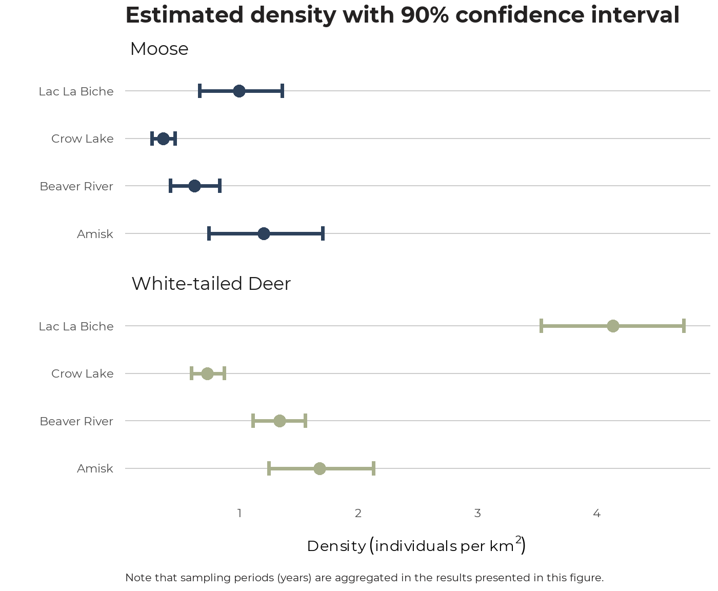
We can visualize the density results (this time aggregated by year, or sampling period) like so:
df_dens_summary_agg <- sf_wmu %>%
  ace_get_cam(group_id = WMUNIT_NAM) %>%
  ace_join_dens(species = c("Moose", "White-tailed Deer")) %>%
  ace_summarise_dens(group_id = WMUNIT_NAM, agg_samp_per = TRUE, conflevel = 0.9)
Previous: Lure adjustments